Saturday, Sunday, Monday
Sept. 9, 10, and 11
Reykjavik, Reykjavik, Reykjavik (again)
Saturday, Sept 9: Reykjavik: Disembark & tour
As usual on a cruise “debarkation day”, we were up early, getting our luggage out, and having an early breakfast. We were scheduled to leave the ship at 8:20 and were in the lounge awaiting our turn well before that time.
A little explanation…. When we made our reservations, Windstar was using the Reykjavik Grand Hotel as the hotel for guests booking activities with Windstar. I was making our reservations independently but had learned that it simplified things to stay at the same hotel, so I made our reservations at the Reykjavik Grand also. But, in the time since making our reservations, Windstar had changed hotels, to the Borg Hotel. Now our transfers would be going to the wrong hotel and we would have to arrange a taxi to the correct (Grand) hotel. I got with Kuba (the Destination Manager), explained the problem, which he understood as others had encountered the same problem, and he coordinated with the tour and transfer people to make sure we ended up at the right hotel.
For our arrival back in Reykjavik, I had signed us up for a “Panoramic Reykjavik & Viking History” tour, ending with a transfer to our hotel where we would stay for another three nights.

Saying Good-by to the Windstar Star Pride through rain-streaked bus window
As had been normal for most of the week, we started off in a light rain as we filed out to the bus and loaded up. We watched as our luggage was loaded on to the bus also, so we knew it would not be far from us for the day. Our “city tour” started with a ride around the dock area with explanations from our guide why it was arranged as it was. I’m not completely sure that we took so long to leave the dock/harbor area so that we could get a tour, or if the bus just had to take a very circuitous route to get out of the harbor because of its size.
We rode through part of the downtown area and then along the waterfront where Susan and I had walked almost a week ago, including past the Viking Longship sculpture (that really does not represent a Viking ship) and then, very close to the sculpture, by the Hofdi House where presidents Regan and Gorbachev had their meeting in 1986.

The Hofdi House where Regan and Gorbachev had their meeting
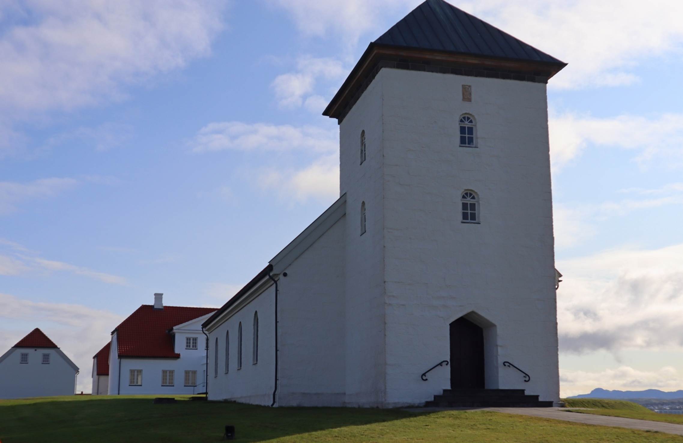
We wound around some of the suburbs, including a area for athletic activities where various teams train and play, and athletes train to represent Iceland in the Olympic games. We made our way to a well known and very visible landmark, Hallgrimskirkja, an imposing Lutheran church that is located on top of a hill in Reykjavik. It was designed by Guðjón Samúelsson, an Iceland State Architect and was completed in 1986. In front of the church is a statue or memorial to the explorer, Leif Erickson, who Iceland claims as a their own, although apparently Greenland also claims him as a being from there.

Famous church with monument to Leif Erikson in front
Mixed in with the very new buildings, like the church, were some rather old and/or traditional buildings, like one old house that had turf grass as its roofing material. The same architect also designed a church that we saw in Akureyri that was similar in style: it was, logically, smaller, but it had two towers of similar design, although much smaller.

There is a normal church behind the huge tower.
Back in the bus, we negotiated some rather narrow streets as we continued the tour of the city. We drove around the University of Iceland and a “city pond”. The next stop turned out to be very interesting: the “Perlan Museum”. (It seemed that any point of interest or attraction in Iceland was labeled as a “museum”.) How the Perlan came about is a bit interesting. The city of Reykjavik built a large water tank on top of a hill overlooking the city to provide good water pressure to the city. Over time, as the city grew, additional tanks were built until there were six tanks built close together. Then new technology came along and the tanks were no longer needed. Rather than tear the tanks down, the city built a structure over the top of the tanks and converted much of the interior space of the tanks into various exhibits and presentations, such as the planetarium that now occupies one of the tanks.
Our tour only had access to the to observation platform level (and the restaurant and gift shop, of course) but the exterior platform did provide a good view of the city and surrounding area.

Entrance to the Perlan “museum”
If you look at the above photo, you can see two of the silver former water tanks with the dome over the top of all six. On the way to the observation level, we looked around the Perlan and thought that it looked rather interesting. Up on the upper platform, we walked around the exterior area, taking in the views of the city. You can get an idea what it looked like In this panoramic video of Reykljavik. From this viewpoint, it is rather obvious that the Lutheran church we had just visited is a major landmark in the city. It is hard to miss in either the photo below or the video.

Part of Reykjavik city with the church tower dominating the view
After enough time to look around, we climbed back in the bus and, once again, wound through some of the local streets, this time on the way to the Alftanes Peninsula, where the Iceland President’s residence is located. Think of this as the Iceland equivalent to our White House in Washington DC, except that there were no guards or security or fences around. There is a very modest church in front of the residence and a couple of out-buildings, but nothing ornate.
Church positioned directly in front of the President’s residence
Off to one side of the church was a small cemetery, but for the most part, there was nothing but grass and open land around the residence. It was on a small peninsular of land that had probably been “reclaimed” from the sea and a short distance away, perhaps a quarter mile, were some normal homes. It was nice to realize that not every political leader has to be heavily protected all the time.

The President’s residence (their White House)
We could walk freely in the area, but our guide just asked that we respect the president’s family privacy and not approach too closely. We walked around a bit, then loaded back on the bus to go to our next stop.
We headed toward the airport, about 45 minutes from town, but turned off the main road just before getting to the airport and stopped at a building labeled as the “Viking World Museum”. Iceland was originally discovered and settled by Vikings from Northern Europe and the people seem to feel a close kinship to their Viking ancestors and appear to keep the Viking spirit of exploration and independence.
There are several displays in the museum, the primary, and largest, one being an exact replica of an actual Viking ship that was excavated in 1882. However, before we started our explorations, we were hungry and admission to the museum included a big helping of Icelandic Lamb soup/stew and bread. We got our food and drinks and took tables located directly underneath the Viking ship: a slightly different view. The soup was definitely hearty and tasty: I’m not a big fan of Lamb, but this soup was good. After eating, we explored further.
The Viking ship is an actual recreation of a traditional long boat. This boat was built in Iceland and in 2000 it was sailed from Iceland to multiple ports in Canada and the US to celebrate the voyages of Leif Erikson a thousand years previously.

The dining area was under the Viking ship recreation.
When looking at the boat, it was a bit amazing that as many as 70 men would man the boat, sometimes rowing, for weeks or months at a time on voyages across the north Atlantic. Thinking back to how the relatively gentle seas moved around our Windstar Star Pride, I could imagine what it would be like in a boat like this.

Consider sailing across an ocean for weeks at a time on this ship.
There were other displays and information about the Vikings and how they lived and explored over 1000 years ago: it was an interesting museum.
Back on the bus, we headed to the airport, only about 10 minutes away, to drop off the people with flights this day. Probably about 10 or 12 people got off and the rest of us headed back to Reykjavbik to our hotels. We were the only people going to the Reykjavik Grand hotel but it was the closest to the main road from the airport, so we got dropped off first, probably about 2:30. As check-in time was 3:00, our room was not ready yet so we found comfortable seats in the lobby and helped ourselves to some coffee and crackers until our room was ready.
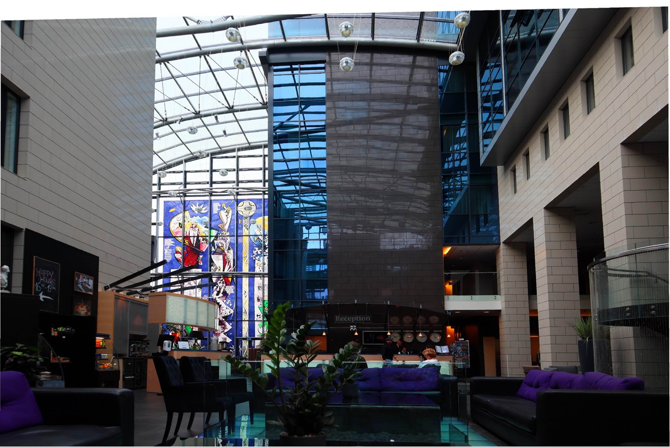
Interior lobby of the Reykjavik Grand Hotel
We had a room with a nice view out over the large bay and much of the city so we rested and enjoyed the view for a while. Although we had been on the tour, we really didn’t do much walking or other significant activity, we we headed out for a walk. We walked down to the same waterfront sidewalk we had taken almost a week earlier, but then turned back toward the center of the city, looking for an interesting place to find some dinner. We came across what must have been a bus terminal with multiple busses and quite a few people getting off the busses, so we thought there should be some restaurants in the area. We found several and chose one that looked a little nicer than the others and headed in: it turned out to be a good choice and we had good meals with enough leftovers for lunch the next day. After the skies got dark, we checked several times for possible northern lights, but the night sky remained completely covered by clouds: no northern lights tonight.
Sunday, Sept 10: Reykjavik: Perlan museum, part 2
Today was the day I had originally scheduled a “Golden Circil” tour, but since we did that as part of our rescheduled Windstar activities, we had a completely open day. We had breakfast at the hotel (which turned out to be a bit hectic as the hotel was apparently the “host” to numerous tour groups from various countries and they seemed to all head to breakfast the same time as we did). It was a bit noisy and not everyone seemed to understand just how a buffet line should work. We also noticed some rather unusual items on the buffet: I’m not sure if these items (like Cod Liver Oil) were the normal fare in Iceland, or to accommodate the various tastes of the travelers.
We discussed what we wanted to do with this “free day” and decided that the Perlan museum seemed interesting and we only saw a small part of it the previous day. In addition, it was just over two miles from the hotel, so it would make for a nice walk there and back, as long as we didn’t get lost. We headed out and made it to the Perlan area in about 35 minutes. Perlan sits on top of a hill and the hillsides all around it are wooded with a number of trails and walkways from the streets below to the parking area and entrance. As we found out later, you could get lost on these trails, but we made it to the entrance and paid for our admission ticket (slightly discounted because we had been there the previous day).

The Perlan “museum”, walking up through the nature trails
The first exhibit we encountered was the Volcano Room. This probably occupied one of the former water tanks and had various displays describing the tectonic plates around Iceland and the resulting volcanic activity. Having seen some of these things first hand on our trip, we probably had a better appreciation of what was being described than other tourists.

Inside the “Volcano Room”: Some of It vibrates with sounds of eruptions.
There was a platform you could sit on in the middle of the room in the shape of a rough map of Iceland that was marked with the tectonic plate boundaries. I think it was supposed to vibrate in time to some of the eruption sounds, but we could not feel any such effect. We did definitely feel some very low frequency vibrations in the walls and in the air as the volcanos erupted on the video screens in the room.
One of the bigger displays was a planetarium, complete with reclining seats and a half-sphere shaped ceiling for projected images. We would not be looking at stars or constellations, as in most such planetariums, but at the Northern Lights. Since we had not been able to see any Northern Lights (Aurora Borealis), we’ll see some in this room. It was a very good show and spent most of the time explaining how the Aurora Borealis is formed and under what conditions, rather than just showing beautiful videos of them. All in all, both beautiful and informative.
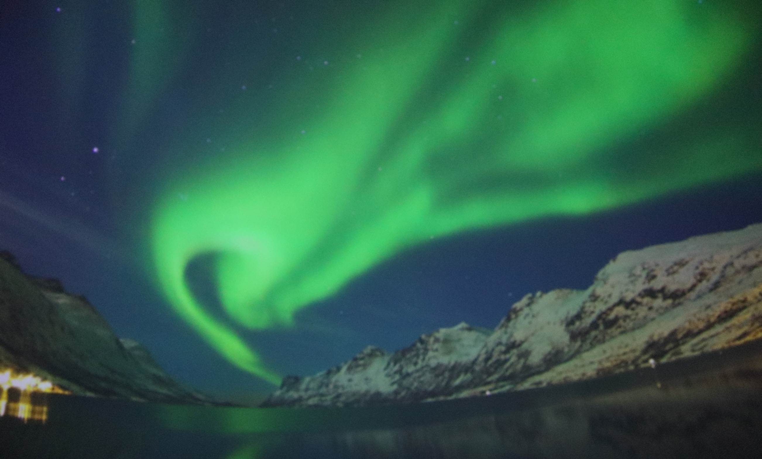
My only photo of the Northern Lights (from inside the planetarium)
Out in the open area of the building was a “bird wall” with lots of birds roosting on it. The birds were not real/alive, but you certainly could not tell at first glance. There were several different kinds of birds, including the cute Puffins, so, like the Northern Lights, what we were unable to see on our cruise, we could see (sort of) in the Perlan. They just need to figure out a way to make some of the birds fly and the effect would be complete. I suspect that, in real life, all these different kinds of birds would not be roosting so close together, but it looked good here.

The “Bird Wall” was a bit static.
Surprise… the Ice Cave was COLD! We got to the entrance to the ice cave just as one of the “guides” was finishing his informative talk about the cave, so I’m not sure what we missed, but we went inside anyway.

It felt colder that 10C (14F) to me!
The sign said it was -10C (14F) inside the cave, but it felt colder than that to me. I have been out in 14F conditions before but I don’t think I have ever felt this intense cold. We had our jackets and gloves on, but after just a couple of minutes I was already well chilled. The total length of the cave was about 100 yards but it seemed longer to me. There were several “decorations” in the cave, such as the throne style chair that you could sit in, but neither of us wanted to sit on anything that cold at that point.

Susan and the “Ice Throne” in the Ice Cave: (She did not sit down.)
We were rather relieved to get out of the cave and decided that we are glad we live where it very seldom gets this cold.
Another room (former water tank) was dedicated to glaciers. It had an interesting piece of technology that mostly worked. If you stood in a specific place (there were shoe outlines on the floor to indicate where to stand) and pointed at a wall in front of you, sensors detected where you were pointing and displayed more detailed information about whatever you were pointing at. It was interesting to play with it a bit, but you had to work at it to get it to function properly.

Susan pointing out items of interest on the special wall
After touring about all the exhibits inside, we took another stroll around the observation deck, checking the landscape. We noticed that there were a lot of kids with bikes and there was some kind of activity with them on some of the trails around the Perlan buildings. I suspect it was some kind of bike-cross (or cycle-cross) event for the younger set. Iceland is very focused on physical fitness and a bike-cross would certainly fit this image.

Some kind of kids biking event outside
Afer looking around a little more, we headed back to the hotel, only taking a slight detour to find our way through the trails surrounding the Perlan. Back at the hotel we attempted to warm up the leftovers from the previous evening’s meal and that was lunch. After the reasonably long walk to the Perlan and back, we relaxed for most of the rest of the day, By late afternoon we were thinking of dinner and thought we’d like a pizza, since we had not had one so far on the trip. I asked one of the desk workers in the hotel and he said that he had just been to a pizza restaurant, very close to the hotel, a couple of days previously. So, we got directions and headed to the Felino Italian/pizza restaurant, only about a 5 minute walk from the hotel. We had a very good pizza and enjoyed a bottle of Italian wine, all with very good service. All in all, a successful day. Well, almost… that evening we checked the skies several times, but the skies remained overcast, so we would not see any northern lights if they did occur.
Monday, Sept 11: Reykjavik: South Coast Tour
Today would be the one day of our trip that actually went as I had initially planned it. I had planned a tour of the southern coastal area because, by this time of our trip, we would have seen much of Iceland and we would have done the Golden Circle the previous day. Well, the rest of the trip may have gone off-schedule, but today worked out well.
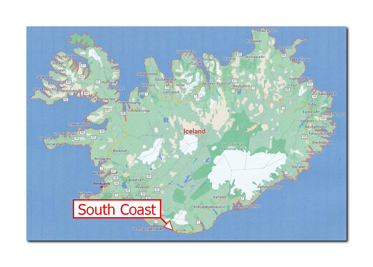
We were to be on a small group tour, and it turned out to be 14 people with a driver/guide in a small tour bus. After another, slightly less hectic, breakfast at the hotel, we waited for our pick-up and left the hotel about 8:25. It was almost 90 minutes to the south coast and our first stop, which was really for a bathroom break and to buy sandwiches and drinks for our lunch later. Another 20 minutes in the bus brought us to out first sightseeing stop, Skogafoss waterfall. (Remember what I told you about what “foss” means.) This was one of several sites we visited today that was featured in the “Game of Thrones” series. Another unrelated legend says that there is a hidden treasure behind the falls, but I was not about to go looking for it.

Skogafoss waterfall and ever present rainbow
There was a walkway with many stairs (417 steps, according to our guide) that you can take to get to the overlook at the top of the falls. As soon as I saw the trail, I knew that Susan would take it as a challenge to make the climb. Our guide said that most people can make the climb in 20 minutes, so, of course, we did it in 15 minutes.

Yes, of course we had to climb up the trail… all 417 steps.
Most of the climb was not bad, but for a significant part of the trail, there were no hand-rails or ropes to hang onto, which made it a little “sketchy” for us. We did have a good view of the upper falls and the surrounding countryside from up there.

The view from the top of the falls
On the way down, it was physically easier, but the lack of hand rails over that steep terrain was more bothersome: I was glad to get down to the bottom. We looked around a little longer and checked the temperature of the water in the river below the falls (cold!) before loading back into the bus and heading out.

Is there a treasure behind the falls?
While riding along the South Coast, I kept looking to the north at what appeared to be a very large (wide, not so high) mountain covered with ice and snow. We had not really seen any other such mountains on our trip. After a while I realized this was actually a glacier (or maybe several glaciers). I knew we had an “encounter” with a glacier later in the day so I wondered if that was where we would be going.

Wherever we went, the glacier was there in the distance.
Our next stop was at the Reynisfjara Beach, or the “Black Beach”. Almost all of the black material was volcanic in origin and there was very little of what we would call “sand”. Most of the beach materials were rocks and pebbles of various sizes. The beach is considered to be very beautiful, but, perhaps because of the cloudy conditions while we were there, it seemed very gloomy and unfriendly to me.

Yes, the Reynisfjara beach was definitely black.
There are some “caves” that the wave action has cut into the cliff along the beach and some strange rock towers out in the water that were apparently formed from lava eruptions thousands of years ago. The effects of the rocks and black beach were a major reason why this was another location for Game of Thrones (season 7) filming. You might get a better feel for the size and feeling of the area from this short video.

It was not an inviting looking beach.
In one section of the cliff, the rocks formed vertical columns with cracks every foot or so, sometimes creating almost a staircase effect. Despite warnings to not climb on the rocks, of course people were doing it. These rocks are basalt and were formed during the eruptions with the wave actions then washing away any soil that had covered them. Rain water would then get into the cracks, freeze and expand, creating larger and larger cracks and the stair-like effect. There were several signs with very strong warnings to not try to swim at this beach: the cold water, crashing waves, and dangerous currents make it rather deadly.

The basalt rocks almost formed steps to climb.
We decided we like white sand beaches and warm water much better than this. After seeing enough, we got out our sandwiches, retreated to the warmth of the bus, and enjoyed our lunch. Next, on to the “big adventure” for the day, hiking on a glacier.
Thankfully, we did not have to go to that glacier I had been watching from the bus. Instead, we drove to a parking lot close to an outlet of a glacier, not even the main glacier itself. Solheimajokull is a outlet glacier coming down from the fourth biggest glacier of Iceland, called Myrdalsjokull. We all got our gear: helmets, ice picks, harnesses, and clamp-ons which would provide traction when walking on the ice. We never really used the picks and our guide said that the harnesses were only to make it easier for him to rescue us if we fell into a crevice. The clamp-ons came in very handy. From the equipment truck, it was about a 15 minute hike to the base of the glacier.

Geared up, hiking to the Solheimajokull Glacier
It was a decent hike just to the base of the glacier, where we stopped and put on our clamp-ons before venturing onto the ice. It was about this point that I realized just how big this glacier was. We’ve been close to glaciers before, in Alaska, but not glaciers like this one. I’ll help you understand the size of the glacier. In the photo immediately below, there are several groups of people standing on various places on top of the glacier: can you find them? Don’t feel bad, I know where they are and I still have problems.

Can you find the people on the glacier in this photo?
The photo below is just a small section of the same exact image above, only I have cropped down to a part and then enlarged that section so you can now actually see the groups of people. Now, go back to the photo above and find those people and look how very small they appear against the size of that glacier. In a little while we will be about where there appears to be four people standing in about the middle of the magnified photo.
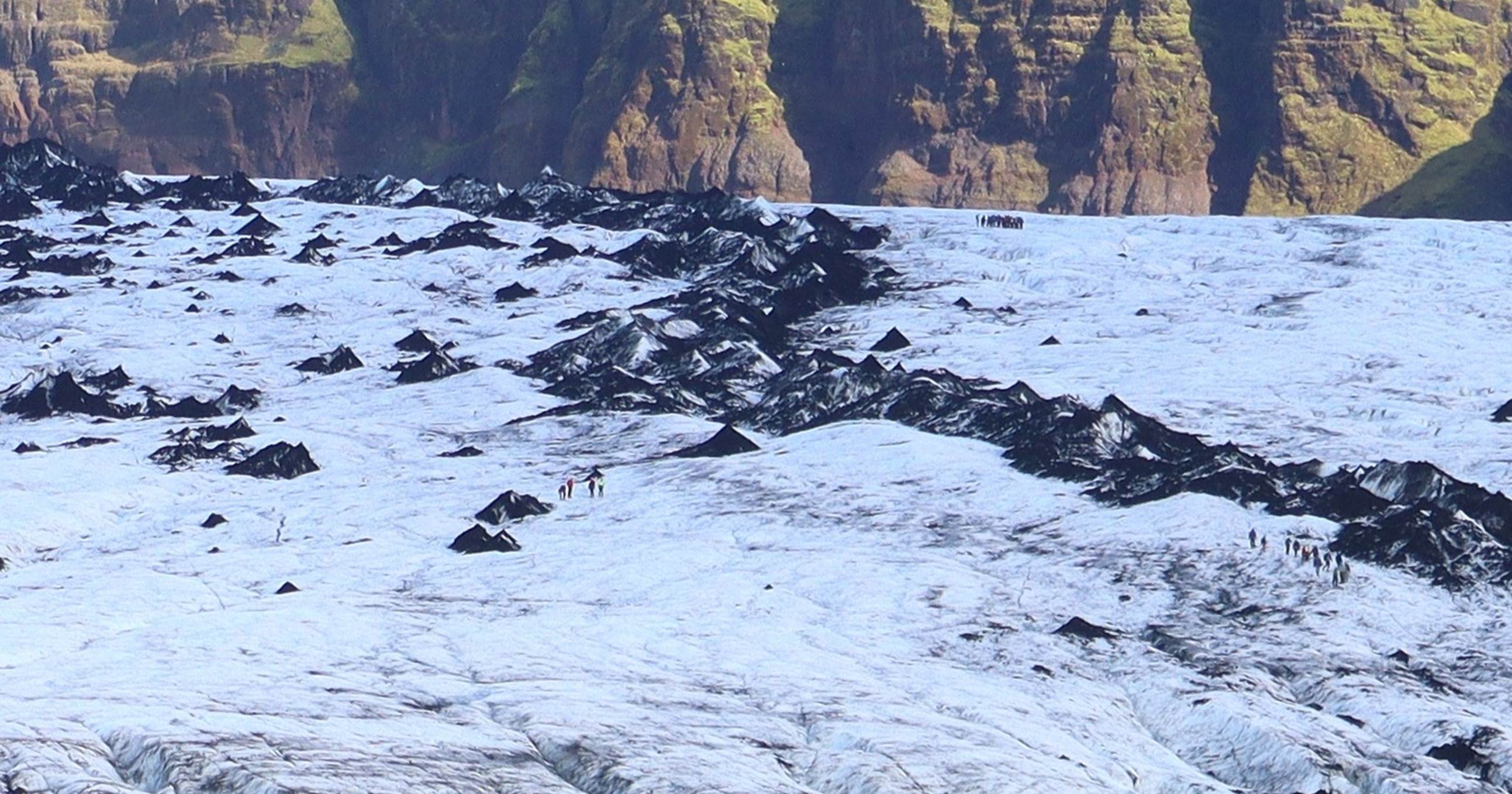
This is a cropped and magnified part of the same photo. Did you find them?
We got to the base of the glacier and started climbing, almost like we were climbing up a dirt hill with chunks of ice scattered about. What looks like black dirt is actually volcanic ash from eruptions that occurred hundreds or thousands of years ago. The ash lands on the surface of a glacier, then a couple of years of snow and ice get deposited, then some more ash, some more ice and … you get the idea. A typical Iceland glacier is sort of like a layer cake, with layers of black ash between the layers of ice. When the glacier moves down a valley and starts melting, the black ash does not melt, so it piles up as a leftover. The closer to the end of the glacier you get, the higher percentage of ash. We initially climbed through mostly black ash, then made our way to the area that was almost all ice.

There is an interesting story about all the “black dirt” around Susan.
We climbed up across the ice toward the open area which was mostly clean white snow and ice. At one point our guide put a pick handle across a small rivulet of melted water and demonstrated a “Viking pushup” so all of us had to demonstrate that we were also capable of doing one (or more) Viking pushups. If you don’t know what a “Viking pushup” is, “Google” it: there are plenty of references.

Pausing to look around from almost the top.
We did have a great view from up on the glacier and you can get an idea from this 360 degree panoramic video from the peak of our climb.
After enjoying the view and the making the experience last as long as we could, we headed back down the glacier and reversed our steps. As we hiked back to the equipment truck, I looked back at the glacier several timers, trying to identify just where we had been. We turned our equipment back in (thankfully, no one had to make use of the harness or helmet) and climbed back into our bus to head to our next stop.
A few miles down the road we stopped at a roadside café and giftshop which was across the road from a somewhat unique view. In 2010 the Eyfjallajokull volcano erupted, spewing tons of ash as high as 40,000 feet, and stopping all air traffic in that region for several days and causing some problems for a couple of weeks, Our guide said that most Icelanders think that this event is what really put Iceland on the world’s map because tourist traffic to Iceland increased dramatically immediately following this eruption.

The Eyfjallajokull volcano that caused air travel problems in 2010
Back into the bus and we headed to our last scenic stop for the day, the Seljalandsfoss Waterfall. This waterfall is popular largely because there is a trail that visitors can take that goes behind the waterfall. Look closely at the photos below and you can see people on the back side of the falling water. Susan and I looked at the trail, at the large volume of mist created by the falls, and at how wet the people were after walking behind the falls and decided that we could skip that experience. At this point, “warm and dry” sounded much better than “wet and cold”.

The Seljalandsfoss Waterfall, with a trail behind the falls
You can probably get a better idea of just how wet it would be behind the falls from this short video. Instead, we took a hike to another, smaller, waterfall about a quarter mile away.

Another rainbow and a very blue sky
A few of the people in our group did make the trip around the back of the falls and they came back to the bus rather wet. We had been watching the sky and had seen that the clouds were clearing off with a blue sky remaining, so we were hoping for the possibility of some Northern Lights. We loaded back into the bus and headed back to Reykjavik and our hotel, about 90 minutes away.
By the time we got to the hotel it was about 7:00 PM and we did not feel like finding another place to eat and leaving the hotel, so we just headed to the hotel restaurant and had sandwiches (good) and a little wine. That night we looked out our window (we could see in the northerly direction) several times, looking for any sign of Northern Lights, but no such luck. We struck out on seeing the Aurora Borealis this time.

Sunset over Reykjavik and another interesting trip
Tuesday, Sept 12: Reykjavik departure
In the morning we had a transfer to the airport scheduled (through Windstar) and it showed up on time at the correct hotel (which I was concerned about) and it was even the same driver as we had on our initial transfer from the airport to the Windstar Pride. Check-in at the airport went smoothly, although some of their security procedures seemed a little strange.
End of Chapter 4: Reykjavik (the second time)
You can now click your “Back button” and return to the main section.